Saturday, December 14, 2019

Flood Prone region


Link to a larger version

The portion of the greater watershed that I have focused on in this study is bounded on the east and west by levees.  Although Federal Emergency Management Agency flood zone maps are only partially available digitally, the area is entirely within the 100 year floodplain (1% chance of flooding in any given year). This is more than appropriate, as the majority of the area floods seasonally every late winter through early spring.  The current water management plan between the USACE and the AGFC has a goal of keeping the maximum water levels below 214' msl, as at this level, nearly 100% of the area is inundated, which displaces upland animals (especially whitetail deer and wild turkey) into the adjacent cropland.  These flood events particularly impact wild turkey, as they often occur during the nesting season in the spring.

Although the hydrology of the surrounding region has been seriously altered by ditching, channelizing, and levees, with the goal of getting the water quickly into the St. Francis River (and holding it there), floods have always been a part of this watershed.  Observing the soils in the watershed can paint a picture of the environmental conditions throughout time that lead to their development.  One attribute of particular importance to wetland habitats is hydric soils.  Hydric soils are defined by the National Resource Conservation Service as soils that formed "under conditions of saturation, flooding, or ponding long enough during the growing season to develop anaerobic conditions in the upper part."  In the field, these soils display observable traits, such as color changes, oxidized root channels, and iron-manganese concretions. The US Department of Argiculture produces maps of soil series, along with descriptions of their attributes (see map above).  Within the focused study area of the Sunken Lands, the vast majority of the soils are hydric (Table 1).  Other than a few small areas of high ground, more than 95% of the area in the Sunken Lands is on hydric soils, or is open water.


Map unit name Hydric Rating Acres in AOI Percent of AOI
Sharkey soils, 0 to 1 percent slopes, frequently flooded 97 23,065.40 55.80%
Mhoon soils, frequently flooded 100 4,701.70 11.40%
Hayti soils 100 3,366.80 8.20%
Commerce soils, 0 to 1 percent slopes, frequently flooded 100 2,254.60 5.50%
Kobel silty clay loam, 0 to 1 percent slopes, frequently flooded 85 1,546.70 3.70%
Water 0 2,697.20 6.50%
Dundee fine sandy loam 10 519.10 1.30%
Dundee silt loam, 0 to 2 percent slopes 10 456.60 1.10%
Amagon fine sandy loam 95 419.80 1.00%
Misc Minor components 2273.47 5.50%
Total Acres 41301.37
Table 1, Soil Series within the Sunken Lands

Invasive animals in the watershed

Saturday, December 7, 2019

Common trees in the watershed

Water sampling ideas for the Sunken Lands

Additional Threats and Challenges

As the Sunken Lands regions has been channelized, and leveed, the surrounding land use has been converted to nearly exclusively row crop agriculture.  Very little consideration has been given to protection of topsoil in the region, as the rich alluvial soils are very deep, the result of thousands of years of alluvial deposits.  This culminates in most fields being left as exposed soil post-harvest, and susceptible to erosion through the winter and early spring, which sees the highest rainfall amounts of the year.  Sediment that is carried through artificially straightened ditches and canals is allowed to flow at a high rate, carrying this load until it gets to the wider, slower, braided areas, and the St. Francis Lake area of the Sunken Lands.

Sedimentation is a concern for both the natural and recreational uses of the Sunken Lands.  Suspended sediment increases turbidity, and limits the penetration of sunlight into the water column.  It also comes with increased nutrients from excess fertilizer, further jeopardizing water quality.  Benthic macroinvertebrates (insect larva and crustaceans that live on the bottom) are often used as a surrogate measure for water quality over long periods, as they are susceptible to extreme events that might not be observed in a one time sample of a particular area.  A study of the benthic communities of the Sunken Lands in 1990 found that the areas with the richest species diversity were those old river channels and oxbow lakes that had the least amount of sedimentation and disturbance from artificial flow regimes.  The channelized sections, and the St. Francis Lake, both had reduced diversity and quantity of sampled species.  (The Aquatic Macroinvertebrates of the St. Francis Sunken Lands in Northeast Arkansas, https://scholarworks.uark.edu/cgi/viewcontent.cgi?article=2234&context=jaas).  This study confirmed that the Sunken Lands is a unique remnant of habitat that serves as a refugium for species that were likely common across the Mississippi Alluvial Valley, but have been extirpated due to habitat loss.  Several species of benthic macroinvertibrates were found that had not been reported in Arkansas, although they would be expected in area.

Sediment deposited in the channels and the lake area creates hazards to boating, and limits fishing and other enjoyment of the St, Francis Lake.  Dr, Neal Vickers of the St. Francis Lake Association recounted that as children the depth in the lake even at water elevations of 208-210' msl were sufficient for swimming and safe boating year round, but the sedimentation has been slowly filling in the lake, and increasing the need for responsibly managed water levels by the AGFC and and USACE.

Image may contain: one or more people, outdoor, nature and water
Summertime kayaking on the proposed paddling trail
St. Francis Lake Association
https://www.facebook.com/StFLake/photos/a.1031775026897651/2581717808570024/?type=3&theater
The popularity of waterfowl hunting on flooded fields within the region offers a potential solution to limit erosion on fallow agriculture fields.  Most fields in the area have infrastructure to hold water for rice production, which allows a shallow flood (6-12 inches) to be held on the fields.  This creates habitat for waterfowl and other migrating birds, replicating some of the natural wetlands that have been lost.  But most importantly, erosion is significantly decreased, as sediment is captured within the fields, and not allowed to run into ditches and make its way into the Sunken Lands.  It also mimics the buffering capacity of wetlands to peak flow rates, by extending the time it takes runoff to work through the watershed, smoothing out peaks in water flow after large storm events.

Saturday, October 26, 2019

A landscape formed by floods

The entirety of the Missisissip Aluvial Valley (MAV) was formed by the ebb and flow of flooding events, and the meandering of ancient channels of the Mississippi, Ohio, and other rivers lost to the sands of time.  The recent story of the Sunken Lands is one of man's desire to tame the floods, and "reclaim" flood prone areas for agriculture.  Historic floods in the region were recorded in 1858, 1862, 1867, 1882, 1884, and 1890.  The St. Francis Levee District was formed in 1893 to begin an organized battle against the unchecked waters.  The Swamp Land Act of 1850 had deeded the majority of flood prone areas to the States to sell, and use the proceeds to fund flood control projects.  Floods continued to affect the area, with notable events in 1903, 1912, 1913, 1915, and 1916.  The 1912 flood in particular was the first to garner significant federal attention, and a colorful recollection of the event by a supervisor of a section of the levee was published by the Arkansas Historical Quarterly in 1947, https://www-jstor-org.ezproxy.lib.vt.edu/stable/pdf/40027473.pdf.

Flooding in the Sunken Lands comes from two directions. Headwater flooding flowing from the headwaters in the mountains of Missouri, and backwater flooding pushing up from the mouth at the Mississippi river.  Two federally funded projects have focused on reducing the impacts of these sources.  Lake Wappapello is situated along the St Francis River channel at the edge of the MAV, and was authorized as a flood management project to hold water and slow the flooding downstream into the Sunken Lands and adjacent agricultural areas.


Near the mouth of the St. Francis River at Marianna Arkansas, the Huxtable Pumping Station and dam was created to restrict the backwater flooding off the main channel of the Mississippi River, but still allow for the flow of water from the St. Francis into the Mississippi.  When the Mississippi reaches 177 feet above sea level, or exceeds the height of the St. Francis, the gates are closed, and the world's largest freshwater storm runoff pumps are turned on to pump the entire flow of the St. Francis River into the Mississippi.

 https://www.mvm.usace.army.mil/Media/Images/igphoto/2000757605/

Flooding continues to be a significant part of the lifecycle of the watershed.  Even with over 120 years of projects and engineering, mother nature has still shown her might with recent major flood events in 2011, 2017, and the longest period of flooding in history in the first half of 2019.  Recent floods have come with significantly less loss of life and property than those of years past, due to the extensive flood control structures that are in place, but I find myself torn.  When I consider the massive loss of habitat that has occurred in the last 200 years, weighed against the production of those lands and the benefits to humans, both locally and worldwide through food production, I often wonder if it was worth the cost. 

A Unique Remnant

Prior to Western settlement, the vast majority of the of the Mississippi River Alluvial Valley (MAV) was criss-crossed with numerous winding, braided channel sloughs, larger meandering secondary rivers (like the St. Francis), and a smattering of abandoned channels and oxbow lakes.  The dominant land cover was bottomland hardwood forests of oaks and other mast producing trees that were adapted to seasonal flooding.  Within the wetter areas were cypress-tupelo swamps with standing water most months of the year.  As permanent European settlers moved west across the Mississippi river, this area was recognized as a having high agricultural potential.  The prevailing view of swamps was very different than today's understanding of the habitat and ecological services they provide, as is summed up well in this article from the Brick and Clay Record printed in January of 1912.  The brick and clay industry was invested in the installation of drain tiles (subterranean clay pipes to drain agricultural lands).  The article is titled WAR DECLARED ON SWAMPLANDS, and here is an excerpt mentioning the St. Francis watershed.
This assault on the natural hydrology and native forests of the region has been the largest threat to the natural habitat in eastern Arkansas and south east Missouri.  Both water and tree were something to be conquered, to be "reclaimed" from a "worthless" state.  The widening and subsidence of the natural channel caused by the New Madrid Earthquakes in 1811-1812 that created the Sunken Lands proved too difficult to completely tame, and the area was instead walled in with massive levees.  This abandonment preserved a remnant of the bottomland hardwood forests and terraces that were once common.

Often when we look at hazards to a watershed, we look uphill.  Although there are no shortage of issues upstream in the watershed that put its future health at risk, this area is unique in that some risks lay downstream.  The construction of the floodway that is mentioned above in the early 1910's diverted a portion of the natural course of the river out of the Sunken Lands into an artificial channel.  A short earthen dam was constructed at the head of the new floodway, essentially creating a reservoir that contained the Sunken Lands above Marked Tree, Arkansas.  In 1926 water control structures were installed at the floodway outfall, and a lock and sluice way were installed at the outfall into the natural channel.  The old channel of the St. Francis was not completely abandoned so it could continue to collect water that fell on the surrounding area outside of the levees, and support commercial boat traffic.  In times of high flow, the majority of the downstream flow was directed down the floodway to prevent flooding along the old channel.  This created two outfall locations that had to be managed in conjunction to maintain water levels within the Sunken Lands.

The soils of the area are silt, clays, and fine sands deposited from alluvial activity of the St. Francis, and historically the Mississippi and Ohio rivers as they meandered through the area in pre-history.  These native soils were used to build the levees, starting as far back as 1893 when the St. Francis Levee District was created.  These soils are not the most stable when saturated, and the combination of two outfalls, and multiple structures, has proven a consistent threat to the maintenance of the water level in the Sunken Lands.  In the 1930's, the original sluice way and lock on south east side of the Sunken lands sustained damage in several successive floods, and was deemed damaged beyond repair during a flood in 1938 that washed out 90 feet of levee.  To the consternation of upstream inhabitants, that relied on an average of 750 lockings per month through the levee, the US Army Corp of Engineers (USACE) determined there was no way to design a robust water control structure that would allow boat traffic through the levee.  An innovative solution to lift the entire flow of the river over, instead of through, the levee was designed by the Memphis District of the USACE.  Three nine-foot diameter pipes were installed to siphon water from the Sunken Lands into the naturally channel of the St. Francis downstream.  These structures are still in use today, and are a highly regarded engineering solution to a specific problem, with no pumping costs, and minimal maintenance.
The dam across the floodway, and the outfalls through it, have not had the same longevity.  The dam has been subject to scouring and overtopping damage multiple times, and the outfalls have gone through several different designs, most recently reducing two floodway water control structures into one in the late 1970's.  The Arkansas Game and Fish Commission (AGFC) currently operates the outfall at the St. Francis Floodway, while the USACE still operates the siphons.  The two agencies have an operating agreement according to the Wildlife Management Area (WMA) Master Plan to maintain the water level in the Sunken Lands at 210 feet above sea level between February and October, and 212 feet above sea level during the waterfowl hunting season of November through January.  This plan approximates the natural cycles of water flow with a focus on creating additional wintering habitat for migrating waterfowl.  The surface area of the lake at the summer pool is approximately 3,122 acres, increasing to 5,474 acres at 212 foot elevation.  Efforts are made in the current management plan to keep the water level below 214 feet to prevent driving whitetail deer and wild turkey out of the WMA.  The lack of higher ground for retreat in flooding events is thought to be a significant hindrance to the management of these two species in particular, especially turkey, as these higher water levels often occur during the spring nesting season.

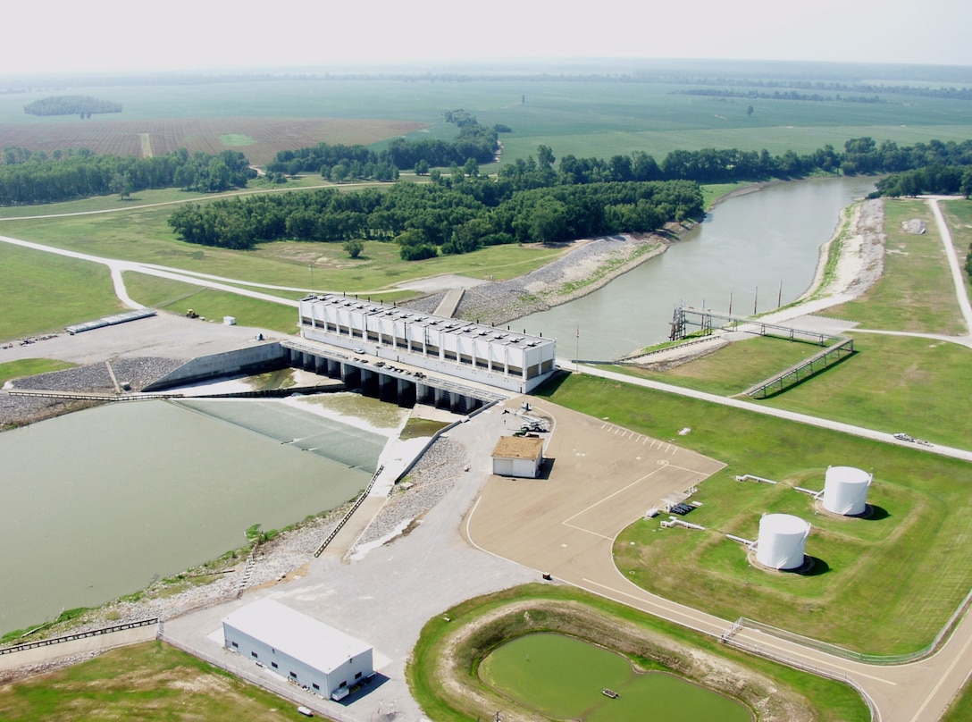
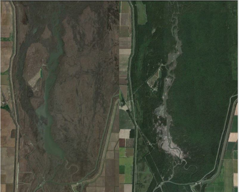
The most recent levee breach initially formed in 2008, and can be seen to the east of the outfall structure in this aerial image above. The repairs to this area were started several times between 2008 and 2017, each time ending in failure due to additional flooding events and shoddy workmanship.  The overflow structure was left open for more than two years starting in 2015 to prevent additional damage to the earthen dam.  During the summers, this left the lake area nothing more than a dry river bed with several shallow, braided channels.  In the winter, the water level could jump up as much as 10 feet after storm event, only to drop back out to a mudflat several days later.  The Google Earth before and after below shows the unmanaged water levels. After almost 10 years of ineffective repairs to the dam, the AGFC reached out the the USACE for assistance in closing the scour, and the dam collapse was finally closed in 2017.
Hopefully this last repair will last, but the modifications to the areas ability to hold water that resembles the pre-settlement condition have historically been a major threat to the continued health of this remnant sliver of habitat.

Additional threats to the habitat quality within the Sunken Lands are increased sedimentation from agriculture runoff that is slowly filling in the lake, invasive woody species (Callery pear Pyrus calleryana), and invasive animals (feral hogs and unwanted beaver activity).  Management of the areas is additionally challenged by mulitple private inholdings.  Over 100 private landowners still hold a smattering of properties within the Sunken Lands, preventing cohesive habitat management, and have generated numerous legal battles associated with the public access for recreation, navigability, and water level maintenance.   

Wednesday, October 16, 2019

The headwaters of the St. Francis start in the Ozark and St. Francois Mountains of south eastern Missouri.  The highest peak in the state, Taum Sauk, at 1759 feet above sea level, is located on the western boundary of the watershed.  The river winds through National Forest Service land through much of its stretch in the mountains, and provides two high class whitewater rafting recreational areas, dropping as quickly as 60 feet per mile.  Right before the river drops out of the mountains into the flatter Mississippi River Alluvial Valley, it travels through the 34 sq km Lake Wappapello and the Wappepello dam, that was constructed in 1941 to help control headwater flooding along the river downstream.

After exiting Wappepello dam, the surround landscape switches from forested mountains to agricultural fields (mostly corn, cotton, rice, and soybeans), as well as some remnant bottomland hardwood forests.  The river forms the western boundary of the Missouri bootheel, serving as the boundary between Missouri and Arkansas.  As the course continues into Arkansas, Crowley's Ridge, an elongated ridge formed by windblown, glacial sediment, rises as the western boundary of the watershed. The next 30 or so miles are the portion of the watershed that I will focus my research on.  The seismic events of the early 19th century created an area of subsidence along the former river channel, deepening and widening the existing channel into an area that earned local names of the St. Francis Lake, and the Sunken Lands.  This area was resistant to over 150 years of "reclamation" of lands into agricultural uses, and has preserved a unique piece of the original bottomland hardwood and cypress swamp habitats that would have been prevalent across the entire Mississippi River valley in Missouri, Arkansas, Tennessee, Mississippi, and Louisiana.

Nearly the entire lower end of the watershed has been surrounded by a levee, separating the majority of the major tributaries from their original flow into the Sunken Land, and not meeting up with the rest of the river until many miles south.  At the southern end of my watershed, near Marked Tree, Arkansas, the majority of the flow of the river has been diverted into an artificial floodway to contain excess flows during high water events, and hold water that floods upstream from the Mississippi River that eventually collects all the rainfall from this area.

When this floodway was created, there was still a desire for a controlled amount of flow to continue down the original St Francis river.  This has created two outfalls from the Sunken Lands, one that sends water down the artificial channel, and one through the original channel, at approximately 210 feet above sea level.  After several engineering challenges with traditional water control structures on the outfall into the natural channel, a truely unique solution was install that lifts the entire flow of the river up and over the levee through a set of three siphons.  There will be more to come on the issues of two outfalls, and the control of the water level in the lake above them.

The entire watershed of the St Francis above the Sunken Lands contains fourteen 10-digit Hydrologic Water Code (HUC) watersheds from the US Geological Survey. This covers an area of approximately 2.5 million acres (the green polygon in the map.)


The focused study area for my blog will be the northern half of the Saint Francis River Floodway - Saint Francis River (HUC 802020309), bounded my the dam/levee that bisects the watershed.  This  is an area of 62,831 acres (the blue polygon in the map.)  The majority of the land in the study area is part of the St Francis Sunken Lands Wildlife Management Area that is owned by the Arkansas Game and Fish Commission, with several notable private in holdings that I will expand on later.

Take a look at the map I have created below, I have also included a link on the left hand nav to a larger version.  The menu buttons on the top right will allow you to toggle different layers on and off, as well as examine different base maps.


Sunday, September 15, 2019

The ground shook for days

The area known as the "Sunken Lands" in northeast Arkansas was formed in the multiple earthquakes from the New Madrid fault in late 1811-early 1812.  This series of earthquakes were the most powerful in recorded history east of the Rockies.  Several of them lasted for hours, with estimates of as many as 2,000 individual occurrences within those short months, and 5 major earthquakes.  They were felt as far east as western New York, and as far south as New Orleans, Louisiana.  Among the many changes to the landscape, the earthquakes caused major subsidence and upheavals as much as 50 feet of elevation change from the existing surface.  Along the St. Francis River, in Clay, Craighead, Greene, and Poinsett counties, around 40 miles of the river bed subsided and average of 20 feet, turning a winding river into a lake, and creating a large network of swamps from grasslands and forests.

Some of the high notes that I will focus on include the effects of this origin story on the settlers on the area, and the continued legacy of disputed property boundaries in the area.  After numerous projects to try and tame the new hydrology in the area through levees and channelization, the most flood-prone regions where left to return to a natural state, preserving a piece of bottomland habitat within a region that has had high conversion to cropland.  The majority of this sunken land has been protected by the state in a Wildlife Management Area, and provides a unique view into the presettlement appearance of the Mississippi Alluvial Valley.  I will also cover the ongoing activities to try and manage the flow of water through the area, and the impacts that has to recreation and wildlife habitat.

This is my first blog, and I'm glad you're here!