
Often when we look at hazards to a watershed, we look uphill. Although there are no shortage of issues upstream in the watershed that put its future health at risk, this area is unique in that some risks lay downstream. The construction of the floodway that is mentioned above in the early 1910's diverted a portion of the natural course of the river out of the Sunken Lands into an artificial channel. A short earthen dam was constructed at the head of the new floodway, essentially creating a reservoir that contained the Sunken Lands above Marked Tree, Arkansas. In 1926 water control structures were installed at the floodway outfall, and a lock and sluice way were installed at the outfall into the natural channel. The old channel of the St. Francis was not completely abandoned so it could continue to collect water that fell on the surrounding area outside of the levees, and support commercial boat traffic. In times of high flow, the majority of the downstream flow was directed down the floodway to prevent flooding along the old channel. This created two outfall locations that had to be managed in conjunction to maintain water levels within the Sunken Lands.
The soils of the area are silt, clays, and fine sands deposited from alluvial activity of the St. Francis, and historically the Mississippi and Ohio rivers as they meandered through the area in pre-history. These native soils were used to build the levees, starting as far back as 1893 when the St. Francis Levee District was created. These soils are not the most stable when saturated, and the combination of two outfalls, and multiple structures, has proven a consistent threat to the maintenance of the water level in the Sunken Lands. In the 1930's, the original sluice way and lock on south east side of the Sunken lands sustained damage in several successive floods, and was deemed damaged beyond repair during a flood in 1938 that washed out 90 feet of levee. To the consternation of upstream inhabitants, that relied on an average of 750 lockings per month through the levee, the US Army Corp of Engineers (USACE) determined there was no way to design a robust water control structure that would allow boat traffic through the levee. An innovative solution to lift the entire flow of the river over, instead of through, the levee was designed by the Memphis District of the USACE. Three nine-foot diameter pipes were installed to siphon water from the Sunken Lands into the naturally channel of the St. Francis downstream. These structures are still in use today, and are a highly regarded engineering solution to a specific problem, with no pumping costs, and minimal maintenance.


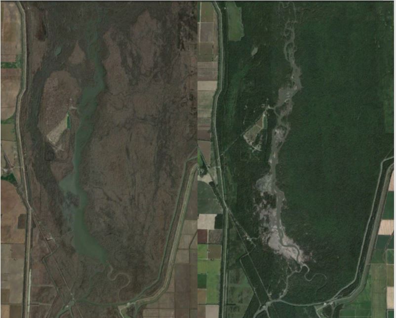
The most recent levee breach initially formed in 2008, and can be seen to the east of the outfall structure in this aerial image above. The repairs to this area were started several times between 2008 and 2017, each time ending in failure due to additional flooding events and shoddy workmanship. The overflow structure was left open for more than two years starting in 2015 to prevent additional damage to the earthen dam. During the summers, this left the lake area nothing more than a dry river bed with several shallow, braided channels. In the winter, the water level could jump up as much as 10 feet after storm event, only to drop back out to a mudflat several days later. The Google Earth before and after below shows the unmanaged water levels. After almost 10 years of ineffective repairs to the dam, the AGFC reached out the the USACE for assistance in closing the scour, and the dam collapse was finally closed in 2017.
Hopefully this last repair will last, but the modifications to the areas ability to hold water that resembles the pre-settlement condition have historically been a major threat to the continued health of this remnant sliver of habitat.
Additional threats to the habitat quality within the Sunken Lands are increased sedimentation from agriculture runoff that is slowly filling in the lake, invasive woody species (Callery pear Pyrus calleryana), and invasive animals (feral hogs and unwanted beaver activity). Management of the areas is additionally challenged by mulitple private inholdings. Over 100 private landowners still hold a smattering of properties within the Sunken Lands, preventing cohesive habitat management, and have generated numerous legal battles associated with the public access for recreation, navigability, and water level maintenance.
No comments:
Post a Comment